mud

feature

myvalleysun.com
January 17, 2015
Bullish on the real news in the Monashee
My Valley Sun
blog
index

Online Community News for Lumby, Cherryville, Rural Coldstream and Highway 6
We update this website on a regular basis. We are eager to receive your news, events, advertising and letters by email at: mediaservices@uniserve.com

MyValleySun.com is community-based media and we help to improve the quality of life in the communities we serve by providing meaningful online news programming that informs, involves and inspires.
Support Local News
Subscribe - Advertise
Contribute - Purchase
Help us connect
the dots...
 | ||||
A store that supports
community-based media
Visit the BullMarket and
support MyValleySun.com
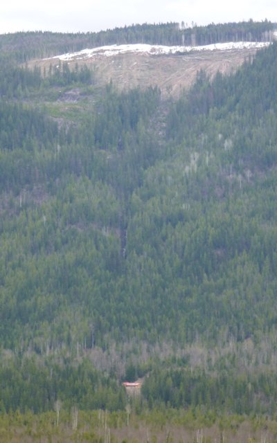


What Could Tolko
Have Been Thinking?
While it's still too early to point blame, this photo suggests an accident waiting to happen as a clearcut looms over a home with a creek and ravine poised to deliver certain disaster.
Indeed, near disaster was delivered.
Photo by Wayne Cunneyworth
clear as
a slide
As a piece of Cherry Ridge gives way, tough questions need to be asked about who's thinking about our interests...
By Don Elzer
April 24, 2012
At 7:30am on Tuesday, Joel and Leanne Hriczu were just beginning to prepare their morning coffee when a loud crash broke the silence of what is normally a quiet and remote setting 12 km north of Cherryville.
“It began with our dog barking but then we heard a loud crash. We ran outside in our bare feet,” said Joel Hriczu, who hours later, still seemed a bit shaken by the experience.
What the Hriczu’s witnessed will remain permanently etched in their memories as the forest directly behind their home could be seen shaking, as trees cracked and folded over - one after another.
“It was like the sound of a helicopter flying very low overhead, and I could feel the ground shake – but then again it might have been my fear that I was feeling,” said Leanne Hriczu.
The Hriczu’s had witnessed first hand, and close up, a mudslide that poured down from the upper reaches of Cherry Ridge bringing with it trees, rocks, debris and water which missed their home by only a few meters.
The Hriczu’s made their way to alert neighbors, one of them Tim Staker.
“We were immediately concerned that a larger portion of the ridge might let go and cause an even larger slide,” said Staker.
As the slide activity calmed it became apparent that the entire landscape had changed. The seasonal creek channel had moved and was held in position by fresh berms of mud. MVS was on the scene by about 1pm and was followed shortly after by a helicopter flying overhead, carrying Tolko representatives who were doing a preliminary site assessment from the air.
By 1:30pm Ministry of Forests, Engineering Technician Bill Henriksen was on the site to examine the damage and to begin to secure the site in order to assess the situation.
“We have to first of all see what caused this event and to determine if there are any public safety risks,” said Henriksen, who added that visuals from the air will help to determine if there is any further event on the ridge that may cause another slide risk.
Communication from helicopter observations suggested that there might not be any further events and that the source may be from an early heli-logging activity believed to have taken place about seven years ago.
According to Henriksen the assessment of the situation is a process that will help to determine if there is fault, or if the slide event was part of a natural occurrence.
“We will bring in a Geotechnical Engineer to examine what has happened here,” he said, adding that at this early stage it’s hard to know how long this process will take before the Ministry has answers.
But for the Hriczu’s and their neighbours, answers need to be forthcoming quickly. If the slide had not made a sudden change in direction just a few meters from their house, mud and debris would have certainly hit the Hriczu home.
The slide’s diversion of the creek made its way to Sugar Lake Road where it had washed out a driveway and silted in a culvert. Argo, the road maintenance contractor was on the scene to assess road conditions and by 3pm a backhoe was on the scene to begin making road and ditch repairs. At that time it was uncertain whether the creek and its increased water flow and silt would reach the Shuswap River.
“We’ve been here 15 years and in that time we have seen logging practices change on the ridge, there’s been a lot more clearcutting”, said Joel Hriczu who suffers from being chemically sensitive and lives in this remote area for health reasons.
Tim Staker echoes Hriczu’s concern and suggests that the slide event may have its beginnings last year when Tolko began logging in an area of the ridge where residents had concerns about runoff.
A warning about clear cutting on Cherry Ridge
The following shaded part of this article is derived from a Cherry Ridge Management Committee Community Report written in July 2011
As early as July of 2011 locals were sounding the alarm. According to a Cherry Ridge Management Committee Community Report, approximately 40 Cherryville residents met Tolko representatives at the Cherry Ridge Forest Service Road to tour Tolko’s planned cut blocks on Cherry Ridge beginning with cut block SUG027, which is now part of a cutblock called SU025 and believed to be within the immediate proximity of the slide area.
At the times, thirty-five concerned residents, including families with children, many of whom live directly below the harvest area, listened to introductions, with Murray Wilson of Tolko giving an overview of Forest Stewardship Plans, Tolko Industries and Forest Practices Board audits.
Kathy and Ron Clempson, water license holders below Warnes Road, described some of their issues with block SUG027 (SU025). Every year they get “silted in” with soils similar to those in this block. The slope is steep and they are concerned about soil stability. There is a Non-Classified Drainage (NCD) through the block. Responding to a question from resident Melanie Staker, Wilson said there was no hydrologist report available.
Another resident, Celia Adkins asked why harvesting was being done on Cherry Ridge and why now?
The report quoted Murray Wilson who replied that 14% of BC’s Crown land was set aside as protected (i.e., BC Parks, etc.) and all the remaining area was designated to be harvested by licensees. Tolko had been busy in recent years harvesting Pine beetle kill elsewhere, but was now preparing to harvest (healthy trees) on Cherry Ridge. At the time residents were told that they can expect to see Tolko more active in the Cherryville area in the coming years.
The community report states that Tolko told residents that, “According to a 100-year plan, all merchantable timber stands in the non-protected 86% of crown land will be harvested by licensees, primarily by clear-cutting; within 100 years, including watershed areas.”
In a review of maps for the Cherry Ridge blocks, Wilson stressed that they don’t rely on maps alone for harvesting decisions. They also study aerial photographs and walk the terrain.
Kathy and Ron Clempson described past problems with water flows down the Forest Service Road (FSR) onto Sugar Lake Road. Kathy Clempson said the FSR was never maintained when it was in Weyerhaeuser’s tenure. Wilson said that it was now Tolko’s responsibility to maintain the road. He commented that roads built today are superior to those built 20 years ago and include many more culverts to avoid concentrated flows.
According to the community report, Tolko said that logging operations were planned to start in September of 2011, with just ground-based logging to begin with, followed by cable logging later. At the time Tolko told the community that approximately 60 hectares were to be cut, but that the exact amount was not known at the time.
When asked how close they would be clear cutting to the creeks, Wilson replied that there were different management zones for different classifications of creeks. It was pointed out that there were fish in Schunter Creek. Judy Harris, another resident, said the Shuswap River and some tributary creeks would be future salmon spawning grounds and asked, “Were gravel beds for salmon to be examined?”
According to the report, the tour continued on with 20 local residents to the second stop, off Warnes Road, at block SUG060. The group pointed out that this area is very steep terrain on a shale base with considerable small sized timber. Resident Jim Johnson commented that it was good to have “a lot of eyes” evaluating conditions through local participation in the tour. The group listened respectfully as Tolko reps discussed potential options for the block.
Another resident, Sean Ardis noted that there is often a change in water flows after clear cuts, from regular flows to fast, short duration flows followed by dry periods. He suggested that (the increased flows) might be okay for some places, but not this particular location.
Kathy Clempson asked if Tolko’s harvest plans for 2011 would be the same as those originally planned by Weyerhaeuser for 2003. Tolko representatives responded that there may be some changes, but the plans will be similar.
Wilson responded to a question about how oil spills and other logging problems would be addressed. He described the process of incident reporting from individual loggers to Tom Jones and Tolko management, up to government agencies.
Sean Ardis wrapped up the tour by stating, “It would be nice to come back here in a year and say Tolko went above and beyond their obligations to demonstrate particular care regarding logging on Cherry Ridge with attention paid to local concerns.”
As history unfolds, Tolko's cut block SU025 appears to be within the immediate proximity to the source of the slide and may now serve as a reminder of how local residents and their warnings were ignored.
By 3:30pm as this story is summarized, the silt and debris from the Cherry Ridge slide has made its way to the Shuswap River where it has defined itself as a discolour that flows to cover one third of the rivers width.
The event will now expand to include the Department of Fisheries and Oceans along with the life that exists in the larger Shuswap watershed that includes salmon.
(30)
Unplanned landscaping
Mud and debris washes out a driveway and ditches at the 12k mark on Sugar Lake Road. The damage tells only a small part of the story.
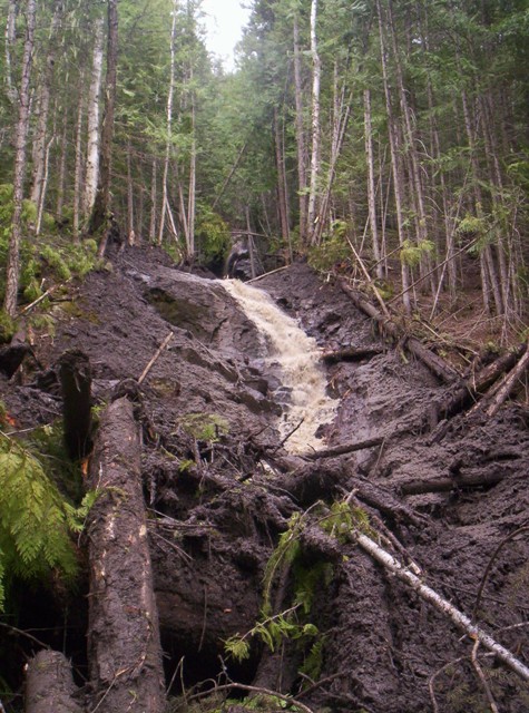
Beauty or the Beast?
Amidst destruction there is a certain beauty that nature carves out from the landscape. A cascading falls emerges, but yet the mud, silt and debris will play havoc on ecosytems.
Too late for the Shuswap River
Silt and mud from the slide have made it to the Shuswap River.
Photo by Tim Staker
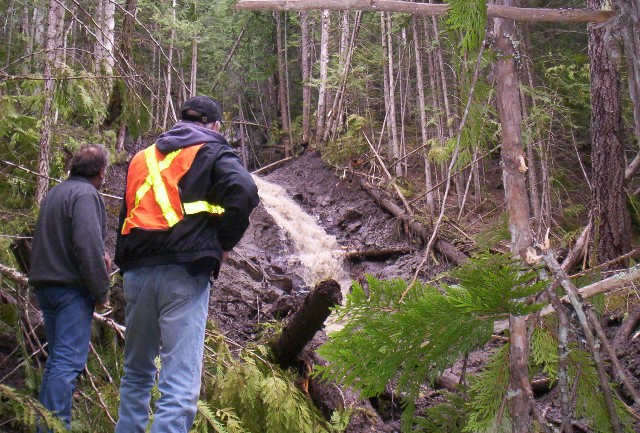
Top Photo:
Joel Hriczu and Ministry of Forests, Engineering Technician Bill Henriksen examine some of the damage caused by the Cherry Ridge slide.

Pledge to My Valley Sun for More News Support
| ||||
Tip the Balance
Support Real News